History
Vegetation
Historically, Mississippi River floodplain habitats in Southern Illinois were expansive tracts of flood-tolerant hardwood forest interspersed with wet meadows, emergent swales, and some mesic prairie. Hackberry (Celtis occidentalis), pecan (Carya illinoensis), and elm (Ulmus spp.) are some of the species that historically dominated the forests that originally covered the Cape Bends SFWA and surrounding floodplain habitats before European settlement. Although these trees still populate the area, massive timber harvesting and clearing for agriculture have left only fragments of forest that resemble historical conditions in the region. Currently, silver maple (Acer saccharinum), cottonwood (Populus deltoides), and various willows (Salix spp.) are often the most common species on intermittently flooded land along the Middle Mississippi River.
Topography and Hydrology
The historical topography of the Mississippi River floodplain was similar to other large river floodplain systems. The ridge and swale topography formed by the alluvial deposits over centuries of flooding supported semi-flood tolerant trees on the tops of ridges, and emergent vegetation and more flood tolerant trees in the lower swales. Some of this topography is still visible on the MMRWFS today, but construction of levee systems and agricultural development resulted in a more homogeneous landscape.
Prior to construction of levee systems, floodplains along the Mississippi were periodically inundated and connected to the main channel of the river during spring floods. Connections between main channel and floodplain habitats were important for exchanges of energy and nutrients between the two systems, creation of spawning habitats for fishes and amphibians, and maintenance of the fertility of floodplain soils. Inundated floodplain habitats were also important to a variety of wildlife species, including waterfowl, wading birds, and aquatic invertebrates. Currently, connections between the Middle Mississippi and its floodplain habitats are limited.
The Great Mississippi River Flood of 1993
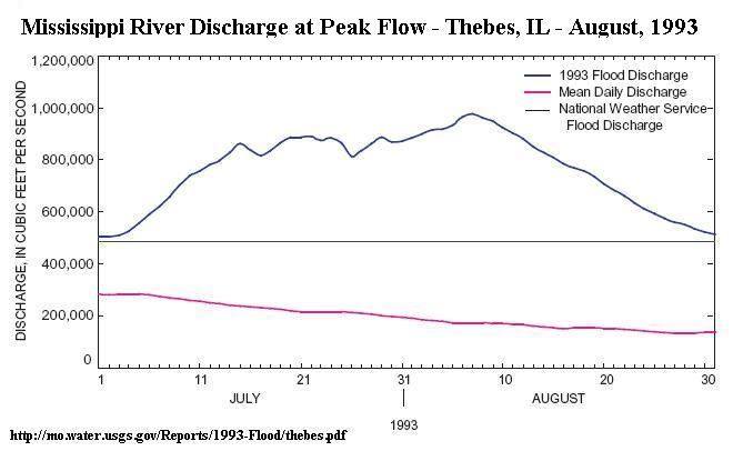
In 1993, the Mississippi River experienced the most severe and devastating flood the United States has seen in modern times. At the Army Corps of Engineers gauging station in Thebes, IL (just South of the MMRWFS,) the river was above flood stage for 133 days between late June and early October. Record water levels overtopped the levees as the river peaked at more than 12 feet above flood stage. Much of the cropland in the area was inundated for months, resulting in over 7 million dollars of agricultural losses. To learn more about the 1993 flood, visit the United States Geologic Survey's 1993 flood website.
Although the flood of 1993 was devastating, it served as a catalyst for significant changes in land use in the region. The land that would become Cape Bend and the MMRWFS is relatively low and prone to flooding. Following a smaller flood in 1996, the American Land Conservancy (ALC), a national non-profit organization, acquired four connecting flood-prone properties that would collectively constitute Cape Bend. After purchasing the property, the ALC facilitated a Wetlands Reserve Program (WRP) conservation easement on most of the property and implemented a massive wetlands restoration on the site in cooperation with the U.S. Natural Resources Conservation Service. The restoration process included ditch plugging and construction of nine wetland cells on the property. Stop-log type water control structures were installed to facilitate drawdown of these wetland units when necessary. The Illinois Department of Natural Resources purchased the land from the ALC in 2002, with the wetland easement in tact, and negotiated a Memorandum of Understanding with Southern Illinois University Carbondale to develop and manage the property as a station for research, demonstration, and education on large river floodplain ecology, restoration, and management.
The Role of SIUC and Partners in Development of the MMRWFS
Dr. Robert Sheehan, of the SIUC Fisheries and Illinois Aquaculture Center and Department of Zoology, worked closely with IDNR (Dan Woolard) and ALC (Jenny Frazier, John Killion) personnel to make the MMRWFS a reality in 2003. Following Dr. Sheehan’s untimely death, Drs. Chris Kohler (Fisheries and Illinois Aquaculture Center and Department of Zoology), Sara Baer (SIUC Plant Biology and Center for Ecology), and Matt Whiles (Department of Zoology and Center for Ecology), with support from Dr. John Koropchak (Vice Chancellor for Research at SIUC) moved the project forward and the station opened it’s doors to researchers in 2006. Dave Maginel, owner of Conservation Technologies, was also instrumental in development of the MMRWFS because of his comprehensive knowledge of the history of the property, local landowners, and restoration and management practices in the region. David Myers, of SIUC Zoology was the first graduate student dedicated to research and development of the site, a project funded by the SIUC Office of Research and Development.
Currently, the main operating funds for the station come from a barge fleeting lease agreement with the Saint Louis Marine Terminal LLC. The MMRWFS is a member of the Organization of Biological Field Stations.